


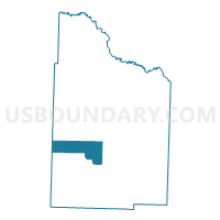
Union Voting District, Nevada County, Arkansas
About
Outline

Summary
| Unique Area Identifier | 527433 |
| Name | Union Voting District |
| County | Nevada County |
| State | Arkansas |
| Area (square miles) | 23.24 |
| Land Area (square miles) | 23.22 |
| Water Area (square miles) | 0.03 |
| % of Land Area | 99.89 |
| % of Water Area | 0.11 |
| Latitude of the Internal Point | 33.60217800 |
| Longtitude of the Internal Point | -93.38806530 |
Maps


Graphs
Select a template below for downloading or customizing gragh for Union Voting District, Nevada County, Arkansas


Neighbors
Neighoring Voting District (by Name) Neighboring Voting District on the Map
- Bodcaw Rural Voting District, Nevada County, AR
- DeRoan Voting District, Hempstead County, AR
- Laneburg/Sutton Voting District, Nevada County, AR
- Rosston Rural Voting District, Nevada County, AR
- Willisville Rural Voting District, Nevada County, AR
Top 10 Neighboring County Subdivision (by Population) Neighboring County Subdivision on the Map
- De Roan township, Hempstead County, AR (13,406)
- Parker township, Nevada County, AR (628)
- Caney township, Nevada County, AR (539)
- Albany township, Nevada County, AR (528)
- Taylor township, Nevada County, AR (524)
Top 10 Neighboring Unified School District (by Population) Neighboring Unified School District on the Map
Top 10 Neighboring State Legislative District Lower Chamber (by Population) Neighboring State Legislative District Lower Chamber on the Map
Top 10 Neighboring State Legislative District Upper Chamber (by Population) Neighboring State Legislative District Upper Chamber on the Map
Top 10 Neighboring 111th Congressional District (by Population) Neighboring 111th Congressional District on the Map
Top 10 Neighboring Census Tract (by Population) Neighboring Census Tract on the Map
- Census Tract 4804, Hempstead County, AR (3,972)
- Census Tract 901, Nevada County, AR (2,490)
- Census Tract 903, Nevada County, AR (1,544)